The Marvelous Malleability of Mobility
July 26, 2019 11:15 am Leave your thoughts
Why was the tree stumped?
It couldn’t get to the root of the problem.
Hello reader – welcome to my fourth Green Dream Job Blog. In this instalment, I’m going to discuss how mobile data collection is changing field operations.
When I started working with Canfor, I was excited to learn that my department has a team devoted to the construction and deployment of mobile applications for data collection. Getting to observe their process has enlightened me to the trials and tribulations that a company can face when trying to balance the implementation of new procedures while still maintaining the requirements of the end user.
Phasing out paper forms comes with reluctance from users who are acclimated to a certain type of workflow, and those who have a preference for not using digital equipment and processes. I can understand how writing on a field card in a trusty ‘Rite in the Rain’ binder is more tangible than a typing on a tablet (especially when it’s raining). With this consideration in mind, I still advocate for using mobile applications in the field. Following workflows on a mobile device can help to improve accuracy and precision, and increase time and cost efficiencies.
Enhanced data integrity and money saved? Sounds like a worthy investment to me. The process to receive these benefits, however, may be a challenging road. Variables at play can include the complexity of the data needing to be collected and the infrastructure hosting it. It is worthy to acknowledge how rewarding even the smallest successes feel after what can be quite a stimulating task.
For example, managing information through a Spatial Database Engine (SDE) allows for multiple users to share the database and simultaneously edit and use the data. This process requires registering the data as versioned; thereby preventing locks or duplication. Managing versions can become difficult when these features are brought into the mobile environment. As field data collection is almost always offline, an intermediary step is required to ‘hold’ the data on the device until the crew is back in reception. This can become even more complicated when processes such as Python scripts are set to run overnight. You certainly don’t want to overwrite the data collected that day, since if the crew is still in the field, there is a good chance it hasn’t been reconciled to the database. Another intricacy of the infrastructure behind mobile data collection is the security measures being used by your organization. For example, if your applications are being hosted online, a Virtual Private Network (VPN) may need to be used to secure the connection between mobile devices and the internet.
With infrastructure aside, the next possible barrier to mobile application deployment is the complexity of data collected. Are you collecting vector (point, line, polygon) data that can be directly loaded into the versioned database? Do you need to visualize a network dataset (ex: roads) to help with routing to your desired location? Would it be easier to get your bearings in the field if ortho-imagery is enabled? Each of these considerations increase the possible size of the data that needs to be loaded onto the device. In an ideal scenario, the folks deploying the mobile applications would have the download size as small as possible (think in the kilobyte (KB) to megabyte (MB) range). Depending on the mobile applications used, there are several tricks that can be utilized to resolve issues around the storage space of a mobile device.
This all sounds interesting, but, how do mobile applications actually benefit business operations? I previously listed improvements to accuracy, precision, and efficiencies. We’ve probably all seen the illustration differentiating accuracy and precision:
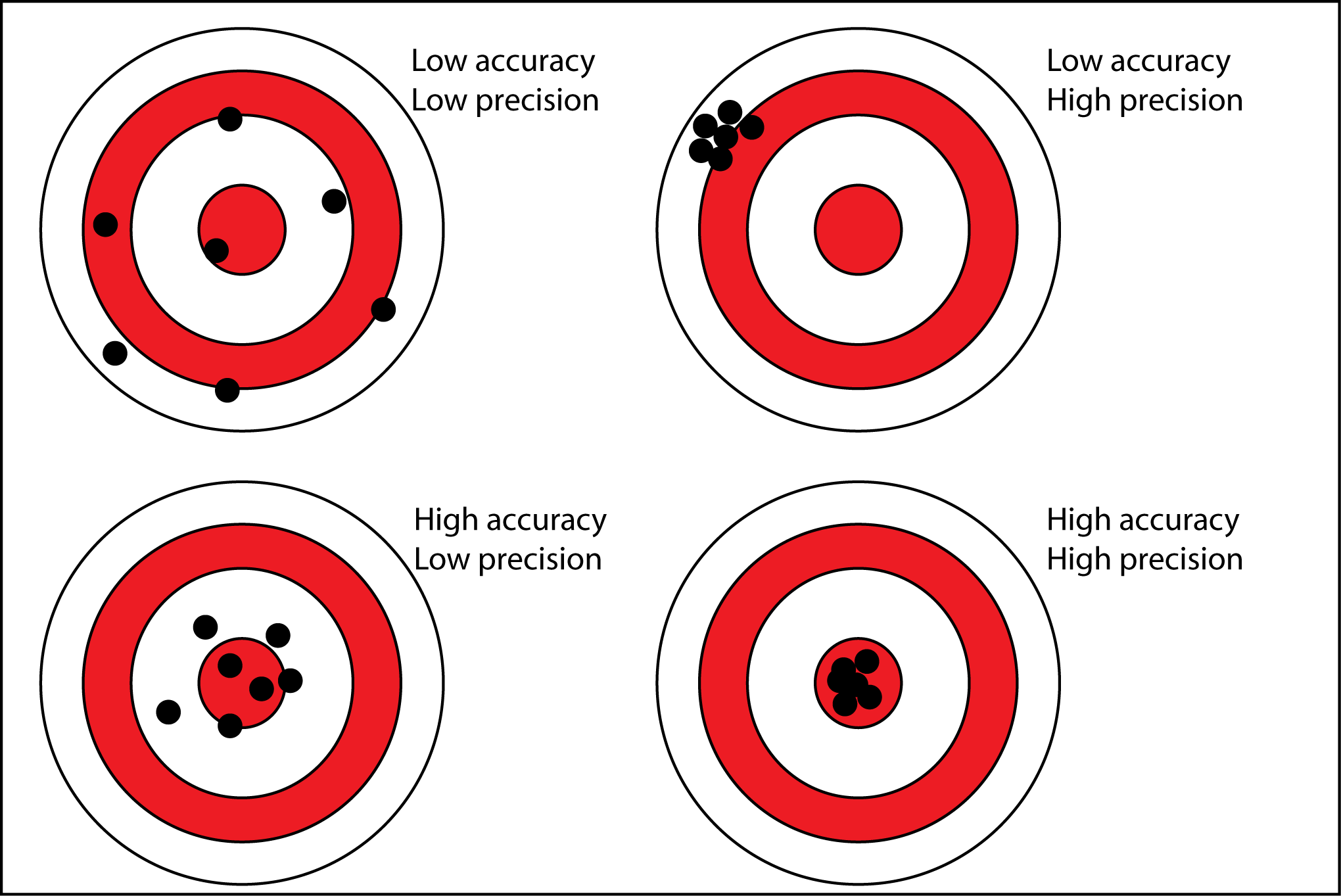
(Reddit 2018)
How do we reach the bullseye demonstrating high accuracy and precision in mobile data collection? While there are known limitations to GPS locations collected with mobile devices (accuracy range of +/- 10 metres), the quality of the tabular data collected can greatly increase. Accuracies can be improved with mobile data collection through such techniques as:
- drop down menus with pre-defined options for selection (ex: stream classification codes)
- intuitive options (ex: user enters cutblock prefix and the selections only include what they have typed)
- radio buttons (ex: harvest method)
- built-in algorithms for any required calculations
This may be a stretch to some, but, I believe precision is improved through mobile data collection by skipping the intermediary step of having a person load data into the database. When this is automatically completed by a device, transcription errors can be avoided and the measurement taken in the field is exactly what is loaded into the system.
Time efficiencies are improved by: less time spent in the field; reducing effort spent making calculations; reducing wait time for tasks to be completed before the next phase of work can begin (ex: data loading); and enabling immediate use of data collected through services for querying and analysis. Cost efficiencies are improved, in part, through the changes to time efficiencies. There can be a greater return when staff are spending less time at some of the intermediary stages, or, waiting has been eliminated entirely. Now that we’ve looked at mobile applications from multiple angles, what is out there waiting to be utilized?
An application many folks will be familiar with, Avenza Maps, is a “free” application that allows the user to download maps for offline uses such as navigation, plotting locations, measuring distances and more. One of the stipulations with this application is that a professional subscription is required to enable downloading more than three topographic maps to your device.
(Avenza 2017)
The organization I work for, Canfor, is actively deploying mobile applications offered by Environmental Systems Research Institute (ESRI). Applications offered by ESRI directly correspond with infrastructure such as ArcSDE and Portal for ArcGIS (offered through ArcGIS Enterprise).
The two applications that I would like to briefly touch on are Survey 123 for ArcGIS and Collector for ArcGIS.
Survey123:
This application is form-centric and used for creating, sharing and completing surveys. Essentially, this application enables the digitization of existing paper forms with additional capabilities.
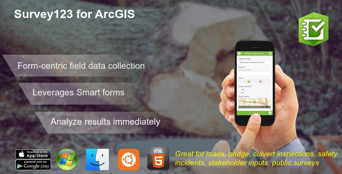
(ESRI Canada 2019)
Collector:
This application is map-centric and used for creating and updating location-enabled GIS features. Accessing and manipulating GIS data can be done entirely from the field, and coming to the office to load data is not necessary.
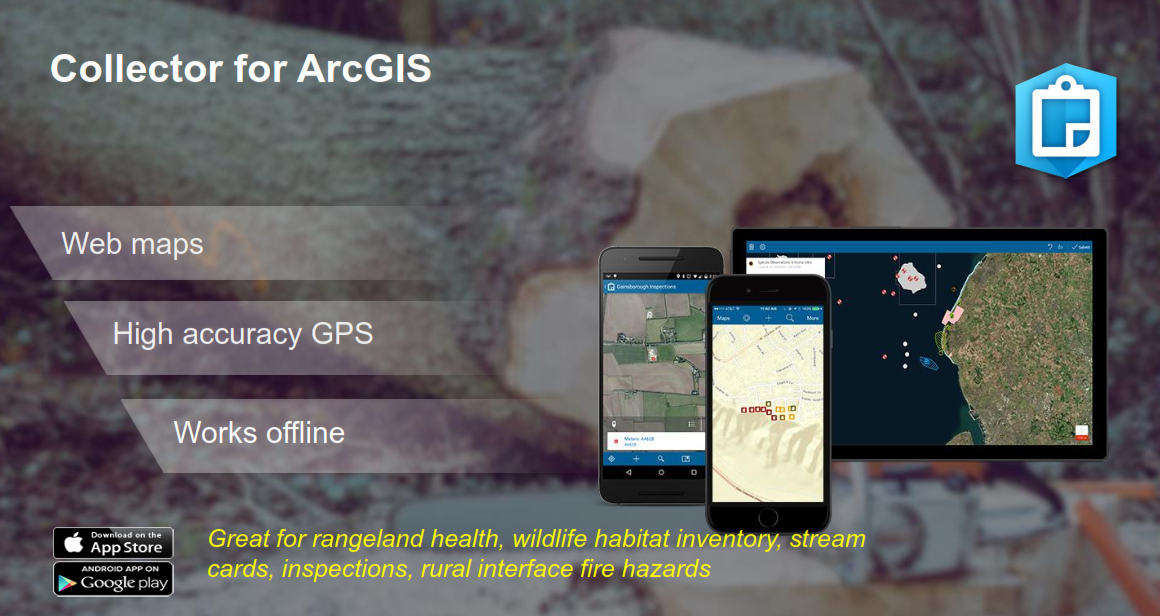
(ESRI Canada 2019)
Thank you for your time and consideration of mobile applications.
References:
Avenza Systems Inc. 2017. Best practices for processing and importing maps into the Avenza Maps app [Internet]. Avenza.com. Available from: https://www.avenza.com/resources/blog/2017/02/09/best-practices-processing-and-importing-maps-avenza-maps-app/.
ESRI Canada. 2019. ArcGIS apps: selecting the right apps for your organization. Esri Canada User Conference. Kelowna (BC).
Reddit. 2018. The difference between “accuracy” and “precision” [Internet]. Reddit.com. Available from: https://www.reddit.com/r/coolguides/comments/9zfg06/the_difference_between_accuracy_and_precision/.